The City of Oxnard uses Landscape Maintenance Districts (LMDs) to finance services throughout the City of Oxnard.
Property owners within these districts are levied an annual special assessment on their Ventura County property tax bills to fund their share of the annual cost of services provided by the district. Proceeds from the special assessments are used to ensure that public improvements are properly maintained.
Engineer’s Report for Landscape Maintenance Districts
The Fiscal Year 2024-25 Consolidated Report includes details about the funding amounts necessary to cover the portion of the estimated costs to maintain, install, operate and service the improvements within each Landscape Maintenance District (LMD) through money received from the assessable real property within the District.

Current Fiscal Year Documents
LMDs Resolution No. 15,779
Intention to Levy for FY24-25
2.94 MB PDF | Updated 06/25/24
LMDs Resolution No. 15,789
Confirming Diagrams and Assessments for FY24-25
7.05 MB PDF | Updated 12/12/23
MAD 4 Mandalay Beach Resolution No. 15,707
Levy a Special Tax Assessment for FY24-25
1.76 MB PDF | Updated 06/25/24
Landscape Maintenance Districts Overview
184.16 KB PDF | Updated 12/12/23
32400240 Mariposa Landscapes Agreement
Landscape Maintenance & Service for LMDs & MAD 4
22.4 MB PDF | Updated 04/03/24
Individual Landscape Maintenance Districts and Maintenance Assessment District
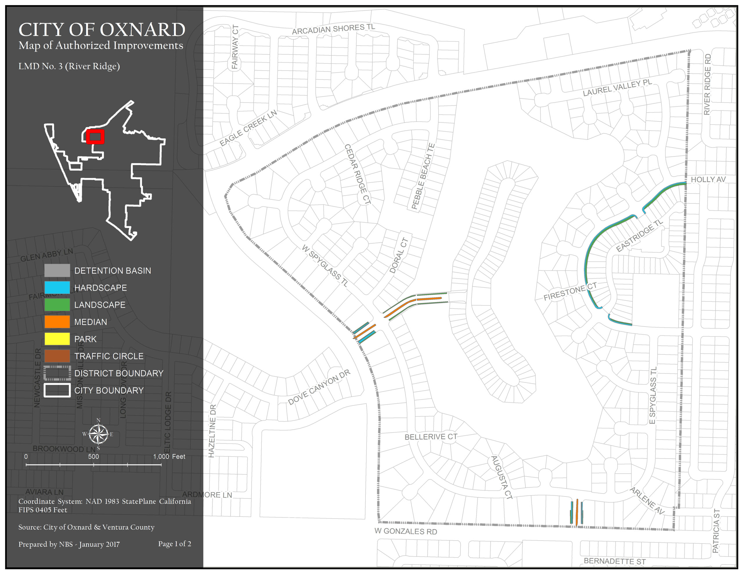
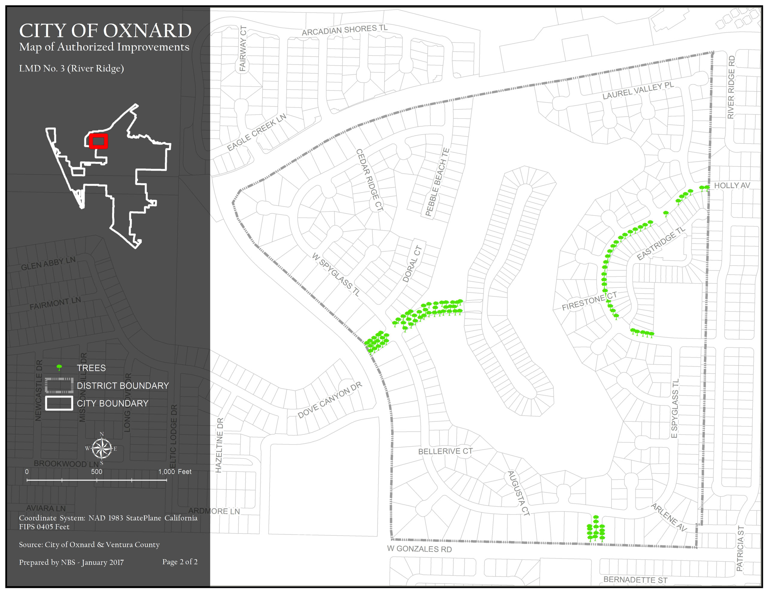
RiverRidge Landscape Maintenance District (No.3) was formed within the City on March 18, 1986.The district generally consists of property north of W. Gonzales Road, east of N. Patterson Road, south of W. Vineyard Avenue, and west of Rhonda Street. Assessments are imposed exclusively to finance capital costs, maintenance, and operation expenses associated with the repairs to trees, shrubs, and ground cover.
Maintenance Service Levels
The current service level in LMD 3 RiverRidge is Service Level A. For a detailed description of what your service level entails, please click the link below.
LMD 3 RiverRidge Map 1 of Authorized Improvements
Hardscape, Landscape, and Median
501.17 KB JPG | Updated 07/02/24
LMD 3 RiverRidge Map 2 of Authorized Improvements
Trees
496.04 KB JPG | Updated 07/02/24
The Maintenance Assessment District (MAD) 4 was formed under the Improvement Act of 1911, so it does not have the same requirements as the LMDs that were formed under the 1972 Landscape and Lighting Act (such as an Engineer’s report). MAD 4 is adjacent to the Waterways Assessment Districts.
Maintenance Service Levels
The current service level in MAD 4 Mandalay Beach is Service Level C for Turf Mowing, Edging & Trimming. All other services such as Trash Removal, Graffiti Removal, Pruning, Weed & Pest Control, and Irrigation Repairs will be serviced by City Staff. For a detailed description of what your service level entails, please click the link below.
Resources
MAD No. 4 Mandalay Beach Annual Report FY 2022-23
814.23 KB PDF | Updated 12/12/23
Resolution No. 8586 Ordering the Formation of MAD-4 Mandalay Beach
234.1 KB PDF | Updated 12/12/23
MAD 4 Mandalay Beach Map 1 of Authorized Improvements
Median, Parking Lot, Planter, Sand Dune, and Turf
5.47 MB PDF | Updated 03/28/24
MAD 4 Mandalay Beach Map 2 of Authorized Improvements
Trees
4.81 MB PDF | Updated 03/28/24
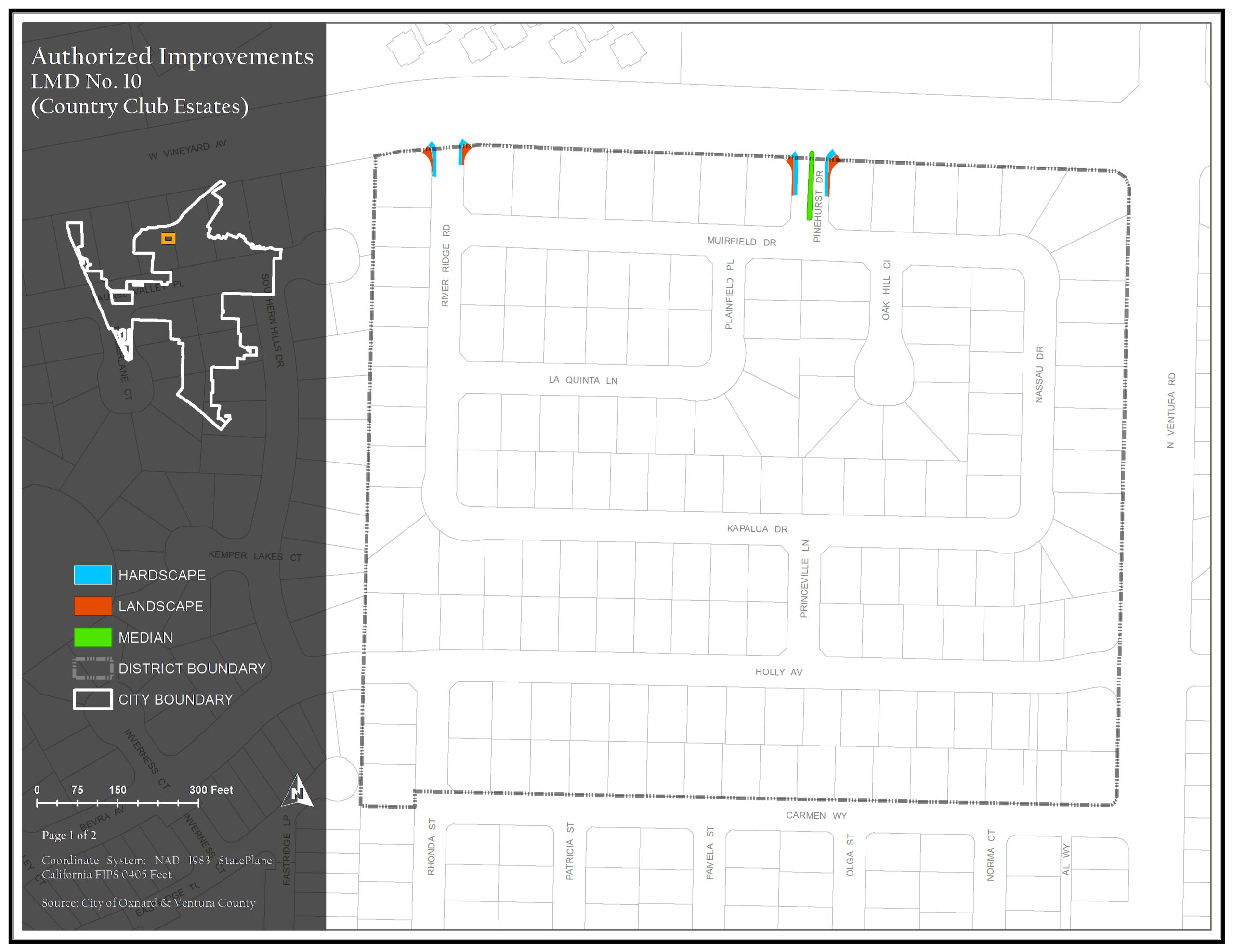
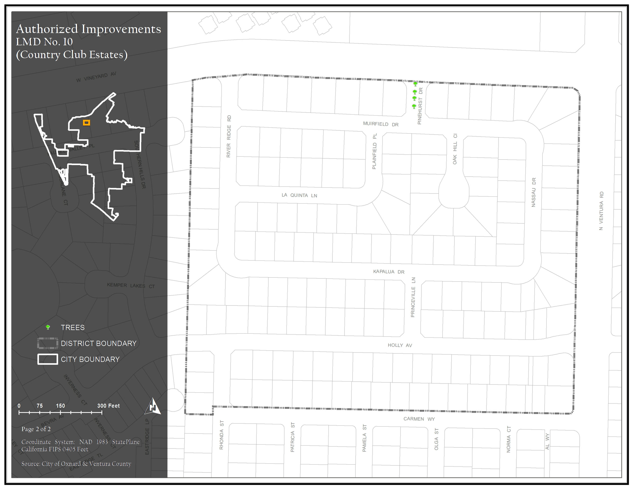
Country Club Estates Landscape Maintenance District (No.10) was formed within the City on December 18, 1988. The district generally consists of property north of Carmen Way, along and east of River Ridge Road, south of W. Vineyard Avenue, and west of Ventura Road. Assessments are imposed exclusively to finance capital costs, maintenance, and operation expenses associated with the repairs to trees, shrubs, and ground cover.
Maintenance Service Levels
The current service level in LMD 10 Country Club Estates is Service Level A. For a detailed description of what your service level entails, please click the link below.
LMD 10 Country Club Estates Map 1 of Authorized Improvements
Hardscape, Landscape, & Medians
350.69 KB JPG | Updated 03/28/24
LMD 10 Country Club Estates Map 2 of Authorized Improvements
Trees
340.12 KB JPG | Updated 03/28/24
St. Tropez Landscape Maintenance District (No.11) was formed within the City on January 3, 1989. The district generally consists of property along and north of Rosebud Drive, east of N. H Street, south of Violet Way, and along and west of Grapevine Drive. Assessments are imposed exclusively to finance capital costs, maintenance, and operation expenses associated with the repairs to trees, shrubs, and ground cover.
Maintenance Service Levels
Landscape maintenance services in LMD 11 St. Tropez is currently being provided by City Staff.
LMD 11 St. Tropez Map 1 of Authorized Improvements
Hardscape and Landscape
1.69 MB PDF | Updated 03/28/24
LMD 11 St. Tropez Map 2 of Authorized Improvements
Trees
1.58 MB PDF | Updated 03/28/24
Standard Pacific Landscape Maintenance District (No. 12) was formed within the City on June 5, 1990. The district generally consists of property along and north of Moraine Way, east of N. Patterson Road, south of W. Gonzales Road, and west of Joliet Place. Assessments are imposed exclusively to finance capital costs, maintenance, and operation expenses associated with the repairs to trees, shrubs, and ground cover.
Maintenance Service Levels
The current service level in LMD 12 Standard Pacific is Service Level A. For a detailed description of what your service level entails, please click the link below.
LMD 12 Standard Pacific Map 1 of Authorized Improvements
Landscape, Median, and Traffic Circle
310.17 KB JPG | Updated 03/28/24
LMD 12 Standard Pacific Map 2 of Authorized Improvements
Trees
303.6 KB JPG | Updated 03/28/24
Le Village Landscape Maintenance District (No.13) was formed within the City on March 20, 1990. The district generally consists of property north of W. Vineyard Avenue, east of N. Ventura Road, south of Stone Creek Drive, and along and west of Larkhaven Lane. Assessments are imposed exclusively to finance capital costs, maintenance, and operation expenses associated with the repairs to trees, shrubs, and ground cover.
Maintenance Service Levels
The current service level in LMD 13 Le Village is Service Level A for Turf Mowing, Edging & Trimming, Weed Control, and Irrigation services. All other services such as Trash Removal, Graffiti Removal, Pruning, and Pest Control will be serviced by City Staff. For a detailed description of what your service level entails, please click the link below.
LMD 13 Le Village Map 1 of Authorized Improvements
Hardscape, Landscape, and Median
1.7 MB PDF | Updated 03/28/24
LMD 13 Le Village Map 2 of Authorized Improvements
Trees
1.59 MB PDF | Updated 03/28/24
California Cove Landscape Maintenance District (No.14) was formed within the City on June 5, 1990. The district generally consists of property north of Stone Creek Drive and along Upper Bay Drive, east and south of N. Ventura Road, and along and west of Honeysuckle Drive. Assessments are imposed exclusively to finance capital costs, maintenance, and operation expenses associated with the repairs to trees, shrubs, and ground cover.
Maintenance Service Levels
The current service level in LMD 14 California Cove is Service Level B for Turf Mowing, Edging, & Trimming, Weed Control, and Irrigation services. All other services such as Trash Removal, Graffiti Removal, Pruning, and Pest Control will be serviced by City Staff. For a detailed description of what your service level entails, please click the link below.
LMD 14 California Cove Map 1 of Authorized Improvements
Hardscape, Landscape, Median, and Traffic Circle
1.91 MB PDF | Updated 03/28/24
LMD 14 California Cove Map 2 of Authorized Improvements
Trees
1.79 MB PDF | Updated 03/28/24
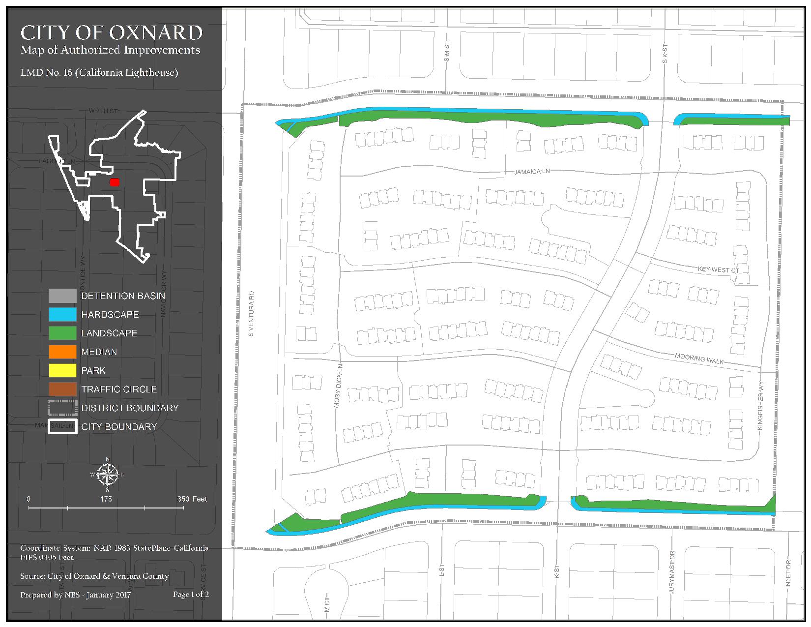
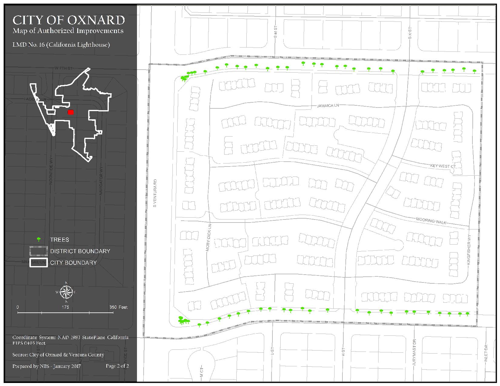
California Lighthouse Landscape Maintenance District (No.16) was formed within the City on July 9, 1991. The district generally consists of property north of Ninth Street, east of S. Ventura Road, south of W. Seventh Street, and west of Kingfisher Way. Assessments are imposed exclusively to finance capital costs, maintenance, and operation expenses associated with the repairs to trees, shrubs, and ground cover.
Maintenance Service Levels
The current service level in LMD 16 California Lighthouse is Service Level A for Pruning for Shrubs, Groundcover, & Vines, Pruning for Trees, and Pest & Weed Control, and Service Level B for Trash and Graffiti Removal services. City Staff will provide Irrigation and Fertilization services. For a detailed description of what your service level entails, please click the link below.
LMD 16 California Lighthouse Map 1 of Authorized Improvements
Detention Basin, Hardscape, Landscape, Median, Park, and Traffic Circle
239.86 KB JPG | Updated 03/28/24
LMD 16 California Lighthouse Map 2 of Authorized Improvements
Trees
230.89 KB JPG | Updated 03/28/24
Greystone Landscape Maintenance District (No.23) was formed within the City on June 18, 1996. The district generally consists of property along and north of Quail Run Way, east of Kentia Street, along and south of Timber Creek Trail, and west of N. H Street. Assessments are imposed exclusively to finance capital costs, maintenance, and operation expenses associated with the repairs to trees, shrubs, and ground cover.
Maintenance Service Levels
The current service level in LMD 23 Greystone is Service Level B. For a detailed description of what your service level entails, please click the link below.
LMD 23 Greystone Map 1 of Authorized Improvements
Hardscape and Landscape
128.43 KB PDF | Updated 03/28/24
LMD 23 Greystone Map 2 of Authorized Improvements
Trees
1.57 MB PDF | Updated 03/28/24
Vineyards Landscape Maintenance District (No.24) was formed within the City on June 18, 1996. The district generally consists of property north of W. Vineyard Avenue, east of Kentia Street, south of Rosebud Drive, and west of N. H Street. Assessments are imposed exclusively to finance capital costs, maintenance, and operation expenses associated with the repairs to trees, shrubs, and ground cover.
Maintenance Service Levels
The current service level in LMD 24 Vineyards is Service Level B. For a detailed description of what your service level entails, please click the link below.
LMD 24 Vineyards Map 1 of Authorized Improvements
Hardscape, Landscape, Median, and Traffic Circle
1.47 MB PDF | Updated 03/28/24
LMD 24 Vineyards Map 2 of Authorized Improvements
Trees
1.52 MB PDF | Updated 03/28/24
The Pointe Landscape Maintenance District (No.25) was formed within the City on June 18, 1996. The district generally consists of property along and north of New Haven Place, east of S. Patterson Road, south of W. Fifth Street, and west of Saratoga Street. Assessments are imposed exclusively to finance capital costs, maintenance, and operation expenses associated with the repairs to trees, shrubs, and ground cover.
Maintenance Service Levels
The current service level in LMD 25 The Pointe is Service Level A. For a detailed description of what your service level entails, please click the link below.
LMD 25 The Pointe Map 1 of Authorized Improvements
Hardscape, Landscape, and Median
1.69 MB PDF | Updated 03/28/24
LMD 25 The Pointe Map 2 of Authorized Improvements
Trees
2.07 MB PDF | Updated 03/28/24
The district generally consists of property north of Raiders Way, east of Dallas Drive, south of Channel Islands Boulevard, and west of Cota Drive. Assessments are imposed exclusively to finance capital costs, maintenance, and operation expenses associated with the repairs to trees, shrubs, turf, sidewalks, screen walls/fencing, and ground cover.
Maintenance Service Levels
The current service level in LMD 27 Rose Island is Service Level B for Turf Mowing, Edging & Trimming, Weed Control, Irrigation, and Shrubs Pruning. All other services such as Trash Removal, Graffiti Removal, and Pest Control will be provided by City Staff. For a detailed description of what your service level entails, please click the link below.
LMD 27 Rose Island Map 1 of Authorized Improvements
Detention Basin, Hardscape, Landscape, Median, Park, and Traffic Circle
2.95 MB PDF | Updated 03/28/24
LMD 27 Rose Island Map 2 of Authorized Improvements
Trees
2.76 MB PDF | Updated 03/28/24
The district generally consists of property north of E. Gonzales Road, east of N. Oxnard Boulevard, along and south of Hermosa Way, and west of Indiana Drive. Assessments are imposed exclusively to finance capital costs, maintenance, and operation expenses associated with the repairs to trees, shrubs, turf, sidewalks, sound and screen walls/fencing, and ground cover.
Maintenance Service Levels
The current service level in LMD 28 Harborside is Service Level A. For a detailed description of what your service level entails, please click the link below.
LMD 28 Harborside Map 1 of Authorized Improvements
Hardscape, Landscape, and Median
3.62 MB PDF | Updated 03/28/24
LMD 28 Harborside Map 2 of Authorized Improvements
Trees
3.62 MB PDF | Updated 03/28/24
The district generally consists of property north of E. Fifth Street, east of S. Rice Avenue, south of Sturgis Road, and west of S. Del Norte Boulevard. Assessments are imposed exclusively to finance capital costs, maintenance, and operation expenses associated with the repairs to trees, shrubs, turf, sidewalks, screen walls/fencing, and ground cover.
Maintenance Service Levels
The current service level in LMD 30 HAAS Automation is Service Level A. For a detailed description of what your service level entails, please click the link below.
LMD 30 HAAS Automation Map 1 of Authorized Improvements
Hardscape and Landscape
1.21 MB PDF | Updated 03/28/24
LMD 30 HAAS Automation Map 2 of Authorized Improvements
Trees
1.21 MB PDF | Updated 03/28/24
The district generally consists of property north of Camino Del Sol, east of N. Juanita Avenue, south of Camino De La Luna, and west of N. Rose Avenue. Assessments are imposed exclusively to finance capital costs, maintenance, and operation expenses associated with the repairs to trees, shrubs, turf, ornamental vegetation, parkways, sidewalks, sound and screen walls, mailboxes, and fences.
Maintenance Service Levels
The current service level in LMD 31 Rancho De La Rosa is Service Level A. For a detailed description of what your service level entails, please click the link below.
LMD 31 Rancho De La Rosa Map 1 of Authorized Improvements
Detention Basin, Hardscape, and Landscape
1.94 MB PDF | Updated 03/28/24
LMD 31 Rancho De La Rosa Map 2 of Authorized Improvements
Trees
2.4 MB PDF | Updated 03/28/24
The district generally consists of property north of E. Gonzales Road, east of Entrada Drive, south of Caliente Way, and west of Indiana Drive. Assessments are imposed exclusively to finance capital costs, maintenance, and operation expenses associated with the repairs to trees, shrubs, turf, sidewalks, sound and screen walls/fencing, ground cover and Borchard Oak Park.
Maintenance Service Levels
The current service level in LMD 32 Oak Park is Service Level A. For a detailed description of what your service level entails, please click the link below.
LMD 32 Oak Park Map 1 of Authorized Improvements
Hardscape, Landscape, and Park
1.11 MB PDF | Updated 03/28/24
LMD 32 Oak Park Map 2 of Authorized Improvements
Trees
1.12 MB PDF | Updated 03/28/24
The district generally consists of property north of Camino Del Sol, east of Kohala Street, south of Jacinto Drive, and west of Paseo Ortega. Assessments are imposed exclusively to finance capital costs, maintenance, and operation expenses associated with the repairs to trees, shrubs, turf, sidewalks, sound and screen walls/fencing, and ground cover.
Maintenance Service Levels
The current service level in LMD 33 El Paseo is Service Level A for all services except Irrigation service (Service Level B), Weeds Control, and Trash Removal. City Staff will provide services for Weeds Control and Trash Removal. For a detailed description of what your service level entails, please click the link below.
LMD 33 El Paseo Map 1 of Authorized Improvements
Detention Basin, Hardscape, and Landscape
1.54 MB PDF | Updated 03/28/24
LMD 33 El Paseo Map 2 of Authorized Improvements
Trees
1.92 MB PDF | Updated 03/28/24
The district generally consists of property north of Camino Del Sol, along and east of Festivo Street, south of Jacinto Drive, and west of Kohala Road and property north of Jacinto Drive, east of Kohala Road, along and east of Ocasa Place and along and west of Paseo Ortega. Assessments are imposed exclusively to finance capital costs, maintenance, and operation expenses associated with the repairs to trees, shrubs, turf, sidewalks, sound and screen walls/fencing, and ground cover.
Maintenance Service Levels
The current service level in LMD 34 Sunrise Point/Sunset Cove is Service Level A. For a detailed description of what your service level entails, please click the link below.
LMD 34 Sunrise Point/Sunset Cove Map 1 of Authorized Improvements
Detention Basin, Hardscape, Landscape, and Traffic Circle
1.61 MB PDF | Updated 03/28/24
LMD 34 Sunrise Point/Sunset Cove Map 2 of Authorized Improvements
Trees
2.17 MB PDF | Updated 03/28/24
The district generally consists of property north of Camino De La Luna and Katrina Way, east of N. Juanita Avenue, south of Cesar Chavez Drive, and west of N. Rose Avenue. Assessments are imposed exclusively to finance capital costs, maintenance, and operation expenses associated with the repairs to trees, shrubs, turf, sidewalks, theme light poles, screen walls/fencing, and ground cover.
Maintenance Service Levels
The current service level in LMD 36 Villa Santa Cruz/Villa Carmel is Service Level B. For a detailed description of what your service level entails, please click the link below.
LMD 36 Villa Santa Cruz/Villa Carmel Map 1 of Authorized Improvements
Detention Basin, Hardscape, Landscape, and Traffic Circle
208.9 KB PDF | Updated 03/28/24
LMD 36 Villa Santa Cruz/Villa Carmel Map 2 of Authorized Improvements
Trees
2.88 MB PDF | Updated 03/28/24
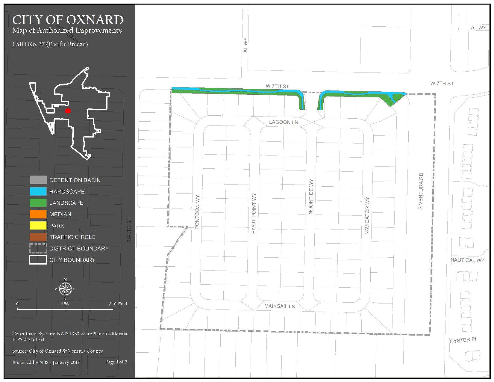
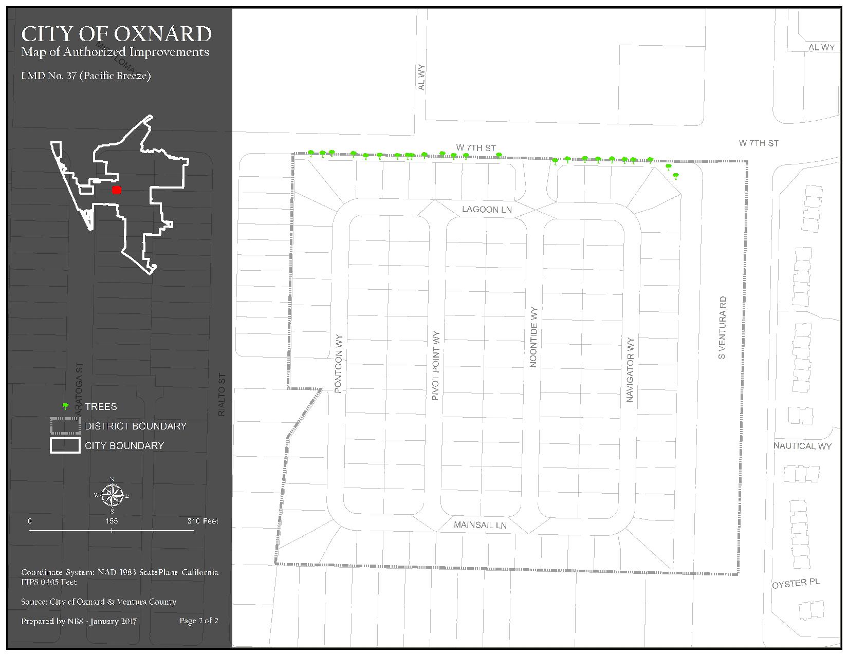
The district generally consists of property along and north of Mainsail Lane, east of Rialto Street, south of West Seventh Street, and west of S. Ventura Road. Assessments are imposed exclusively to finance capital costs, maintenance, and operation expenses associated with the repairs to trees, shrubs, turf, sidewalks, and ground cover.
Maintenance Service Levels
The current service level in LMD 37 Pacific Breeze is Service Level A. For a detailed description of what your service level entails, please click the link below.
LMD 37 Pacific Breeze Map 1 of Authorized Improvements
Detention Basin, Hardscape, Landscape, Median, Park, and Traffic Circle
177.86 KB JPG | Updated 04/03/24
LMD 37 Pacific Breeze Map 2 of Authorized Improvements
Trees
170.4 KB JPG | Updated 04/03/24
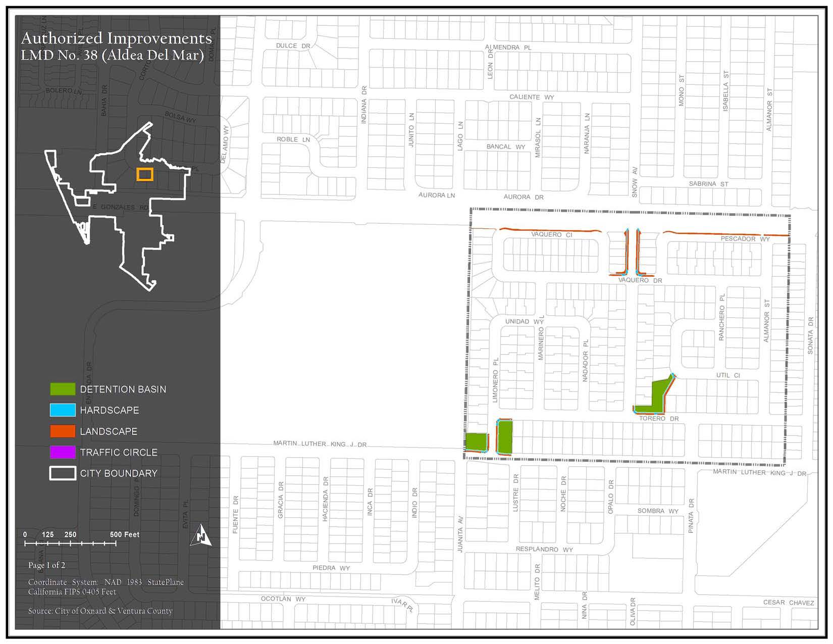
The district generally consists of property north of Martin Luther King Jr. Drive, along and east of Limonero Place and Vaquero Circle, south of E. Gonzales Road, and west of Sonata Drive. Assessments are imposed exclusively to finance capital costs, maintenance, and operation expenses associated with the repairs to trees, shrubs, turf, sidewalks, theme light poles, screen walls/fencing, and ground cover.
Maintenance Service Levels
The current service level in LMD 38 Aldea Del Mar is Service Level B. City Staff will provide services for Trash Removal and Irrigation services. For a detailed description of what your service level entails, please click the link below.
LMD 38 Aldea Del Mar Map 1 of Authorized Improvements
Detention Basin, Hardscape, Landscape, and Traffic Circle
179.01 KB JPG | Updated 04/03/24
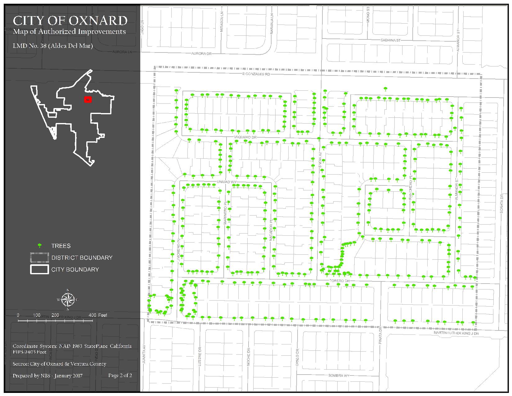
LMD 38 Aldea Del Mar Map 2 of Authorized Improvements
Trees
269.19 KB JPG | Updated 04/03/24
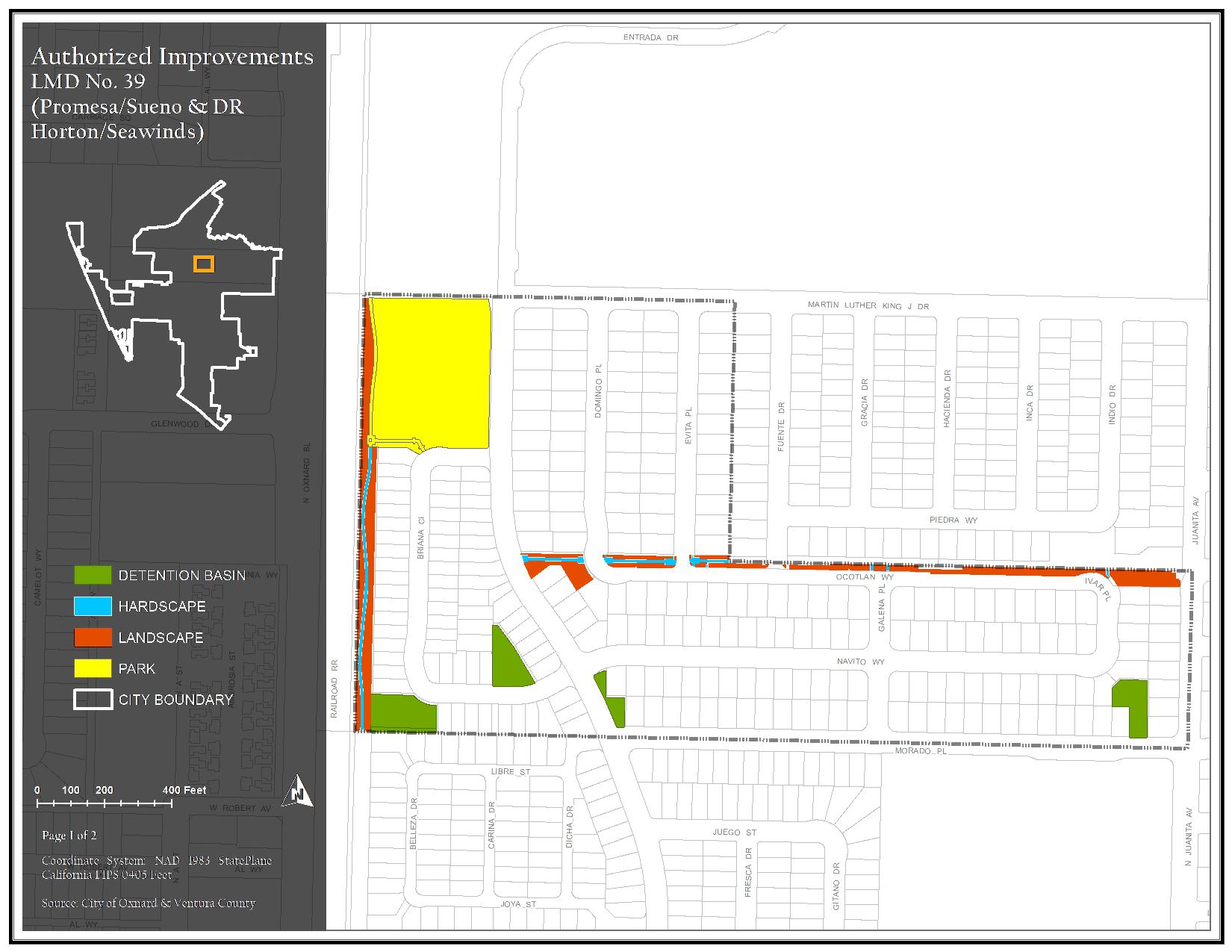
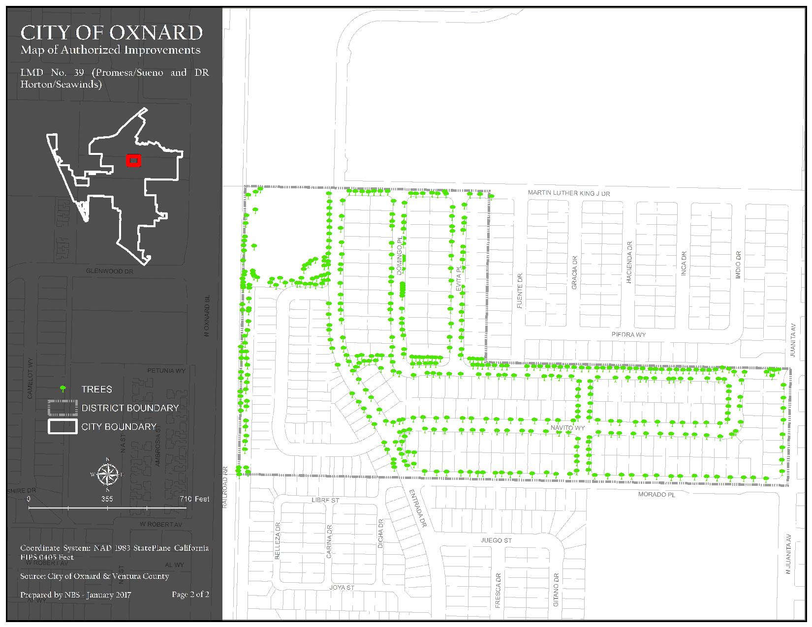
The district generally consists of property north of Morado Place, east of N. Oxnard Boulevard, south of Martin Luther King Jr. Drive and Ocotlan Way, and west of N. Juanita Avenue. Assessments are imposed exclusively to finance capital costs, maintenance, and operation expenses associated with the repairs to trees, shrubs, turf, sidewalks, theme light poles, screen walls/fencing, mailboxes and ground cover.
Maintenance Service Levels
The current service level in LMD 39 El Sueno Promesa/DR Horton/Seawinds is Service Level A. City Staff will provide services for Irrigation and Fertilization. For a detailed description of what your service level entails, please click the link below.
LMD 39 El Sueno Promesa/DR Horton/Seawinds Map 1 of Authorized Improvements
Detention Basin, Hardscape, Landscape, and Park
220.03 KB JPG | Updated 04/03/24
LMD 39 El Sueno Promesa/DR Horton/Seawinds Map 2 of Authorized Improvements
Trees
240.57 KB JPG | Updated 04/03/24
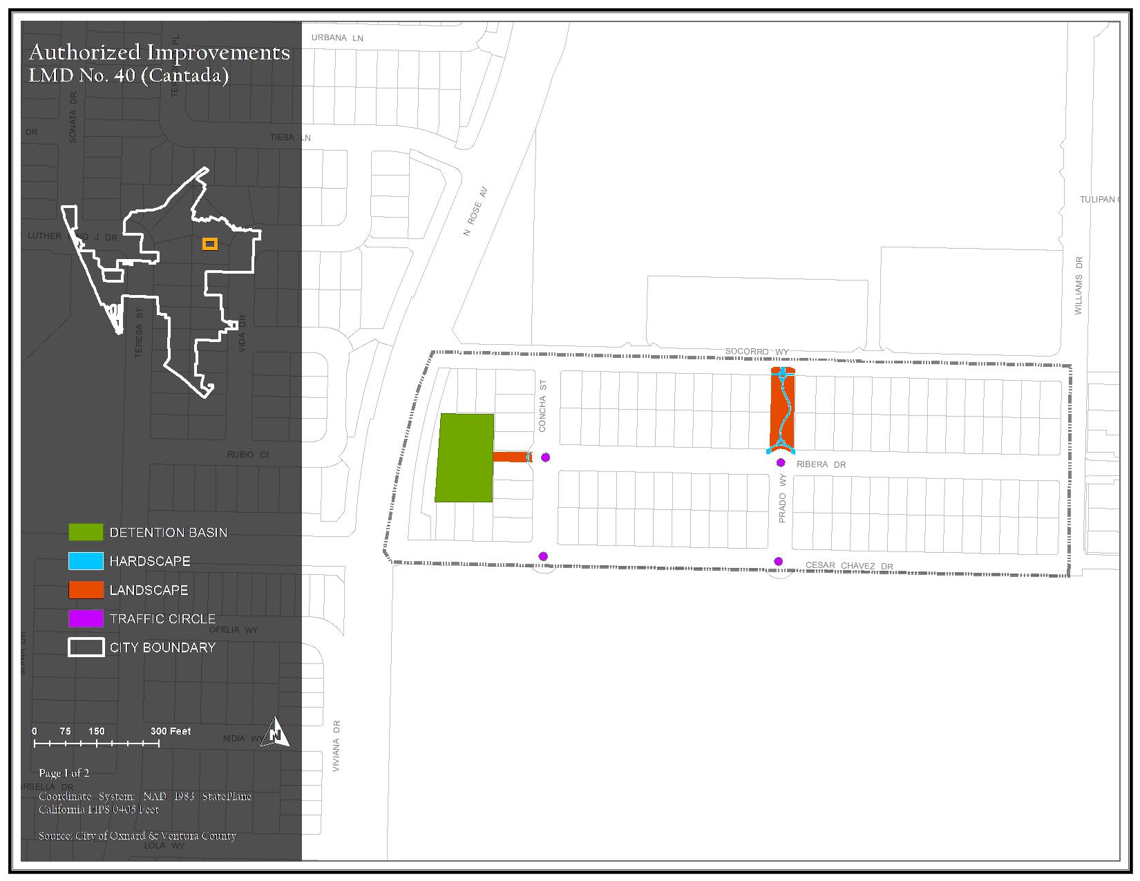
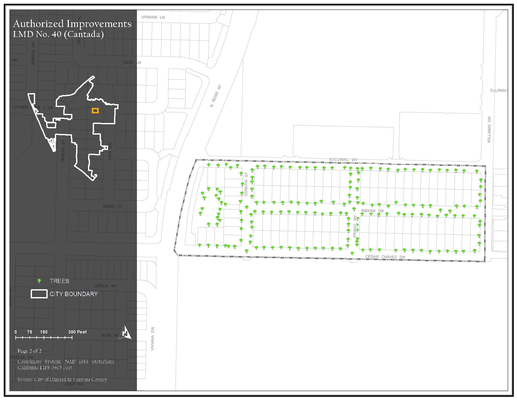
The district generally consists of property north of Cesar Chavez Drive, east of N. Rose Avenue, south of Socorro Way, and west of Williams Drive. Assessments are imposed exclusively to finance capital costs, maintenance, and operation expenses associated with the repairs to trees, shrubs, turf, sidewalks, theme light poles, screen walls/fencing, and ground cover.
Maintenance Service Levels
The current service level in LMD 40 Cantada is Service Level A. For a detailed description of what your service level entails, please click the link below.
LMD 40 Cantada Map 1 of Authorized Improvements
Detention Basin, Hardscape, Landscape, and Traffic Circle
167.61 KB JPG | Updated 04/03/24
LMD 40 Cantada Map 2 of Authorized Improvements
Trees
179.96 KB JPG | Updated 04/03/24
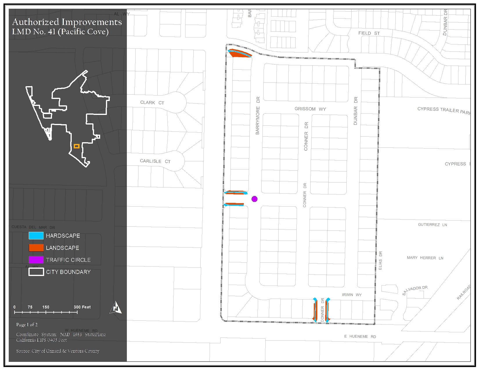
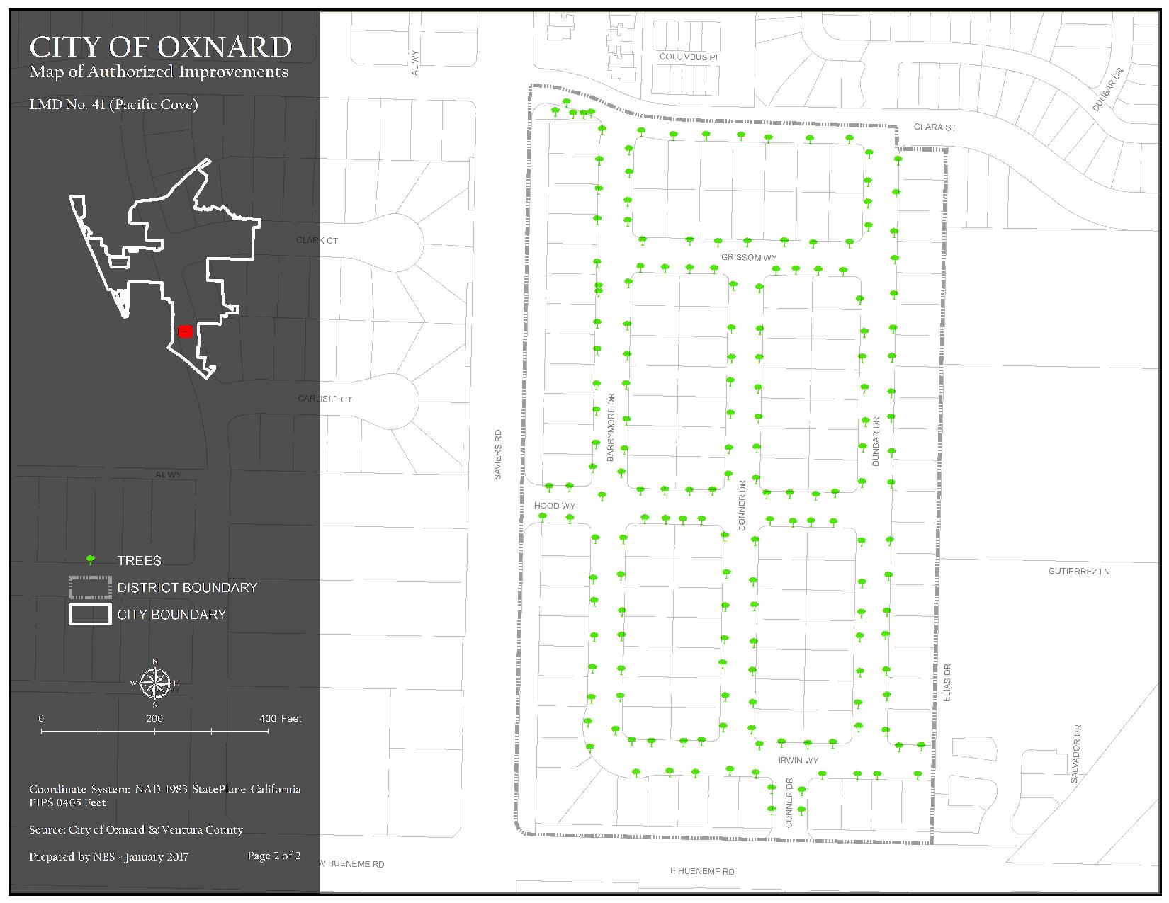
The district generally consists of property north of E. Hueneme Road, east of Saviers Road, south of E. Clara Street, and along and west of Dunbar Drive. Assessments are imposed exclusively to finance capital costs, maintenance, and operation expenses associated with the repairs to trees, shrubs, turf, sidewalks, theme light poles, sign monuments, and ground cover.
Maintenance Service Levels
The current service level in LMD 41 Pacific Cove is Service Level A. For a detailed description of what your service level entails, please click the link below.
LMD 41 Pacific Cove Map 1 of Authorized Improvements
Hardscape, Landscape, and Traffic Circle
188.04 KB JPG | Updated 04/03/24
LMD 41 Pacific Cove Map 2 of Authorized Improvements
Trees
187.86 KB JPG | Updated 04/03/24
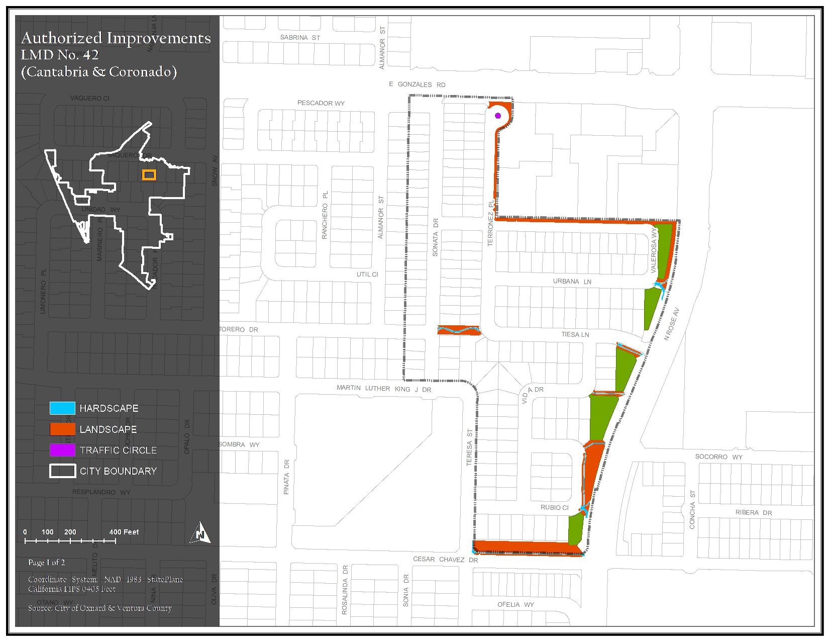
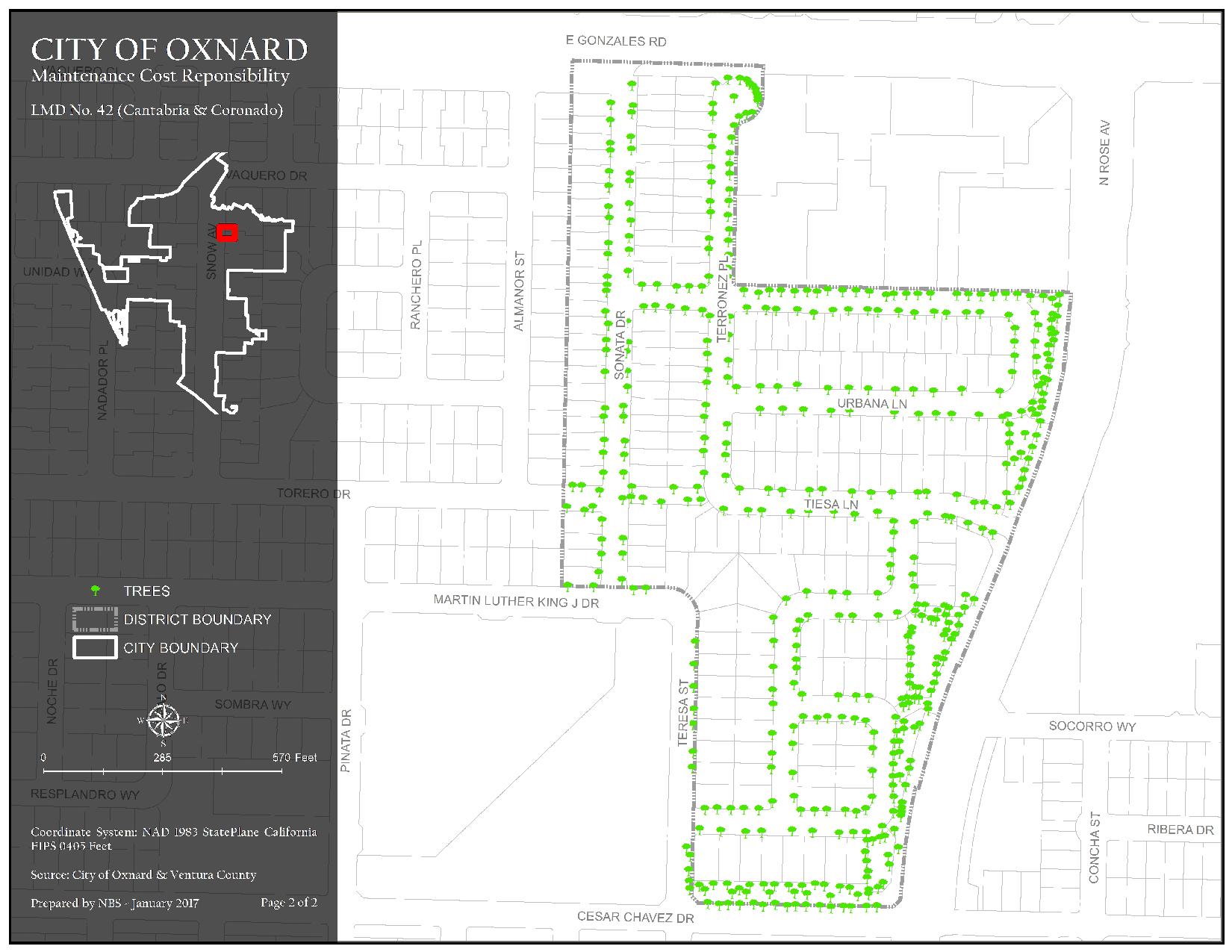
The district generally consists of property north of Cesar Chavez Drive, east of Sonata Drive and Teresa Street, south of E. Gonzales Road, and west of N. Rose Avenue. Assessments are imposed exclusively to finance capital costs, maintenance, and operation expenses associated with the repairs to trees, shrubs, turf, sidewalks, theme light poles, screen walls/fencing, medians, and ground cover.
Maintenance Service Levels
The current service level in LMD 42 Cantabria/Coronado is Service Level A. For a detailed description of what your service level entails, please click the link below.
LMD 42 Cantabria/Coronado Map 1 of Authorized Improvements
Hardscape, Landscape, and Traffic Circle
220.75 KB JPG | Updated 04/03/24
LMD 42 Cantabria/Coronado Map 2 of Authorized Improvements
Trees
237.34 KB JPG | Updated 04/03/24
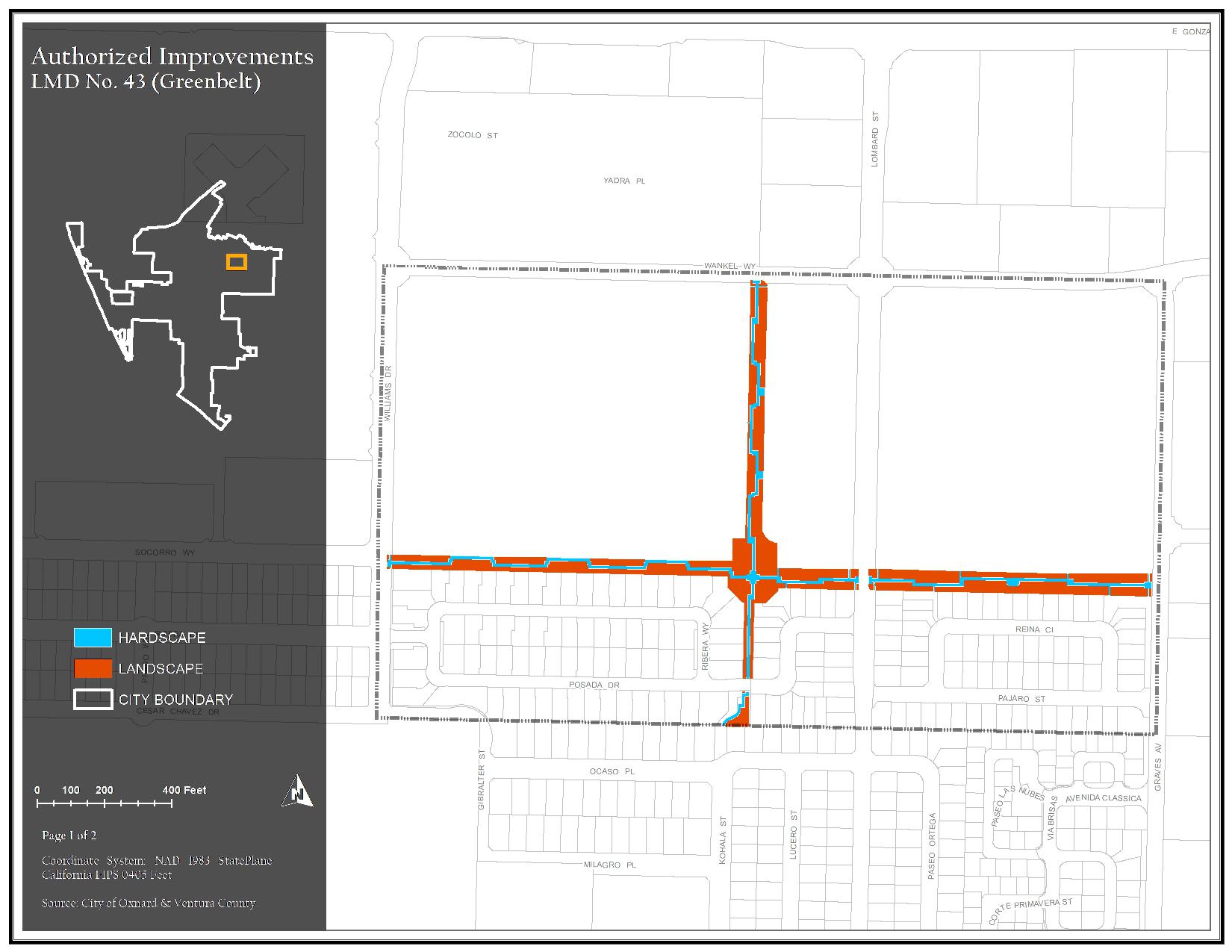
The district generally consists of property north of Cesar Chavez Drive, east of Williams Drive, south of Wankel Way, and west of Graves Avenue. Assessments are imposed exclusively to finance capital costs, maintenance, and operation expenses associated with the repairs to trees, shrubs, turf, sidewalks, theme light poles, park benches, trash containers, overhead structures, screen walls/fencing, and ground cover.
Maintenance Service Levels
The current service level in LMD 43 Greenbelt is Service Level A. For a detailed description of what your service level entails, please click the link below.
LMD 43 Greenbelt Map 1 of Authorized Improvements
Hardscape and Landscape
190.89 KB JPG | Updated 04/03/24
LMD 43 Greenbelt Map 2 of Authorized Improvements
Trees
194.44 KB JPG | Updated 04/03/24
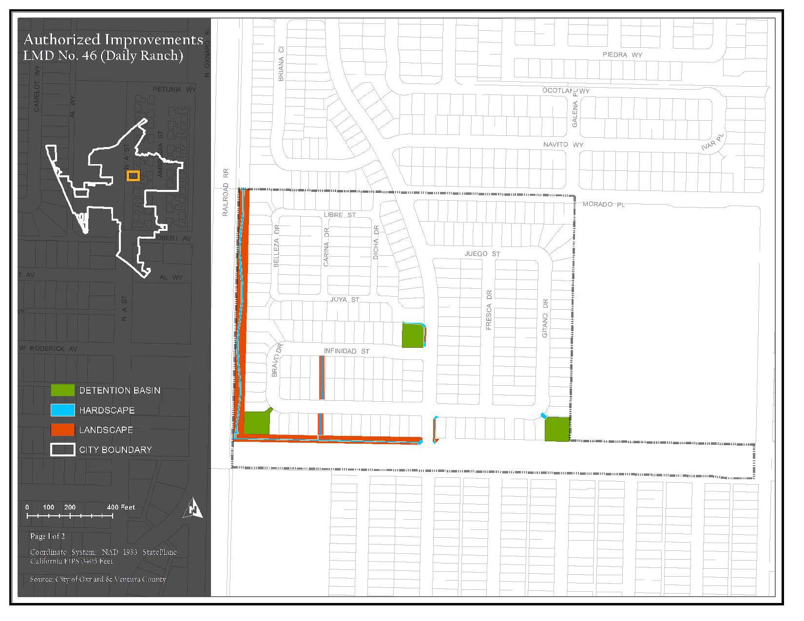
The district generally consists of property north of Camino Del Sol, east of Oxnard Boulevard, south of Morado Place, and west of Robert J. Frank Intermediate School. Assessments are imposed exclusively to finance capital costs, maintenance, and operation expenses associated with the repairs to trees, shrubs, turf, sidewalks, theme light poles, park benches, trash containers, overhead structures, screen walls/fencing, mailboxes, medians, detention basins, ground cover and Promesa/Sueno Park amenities.
Maintenance Service Levels
The current service level in LMD 46 Daily Ranch is Service Level A. For a detailed description of what your service level entails, please click the link below.
LMD 46 Daily Ranch Map 1 of Authorized Improvements
Detention Basin, Hardscape, and Landscape
189.82 KB JPG | Updated 04/03/24
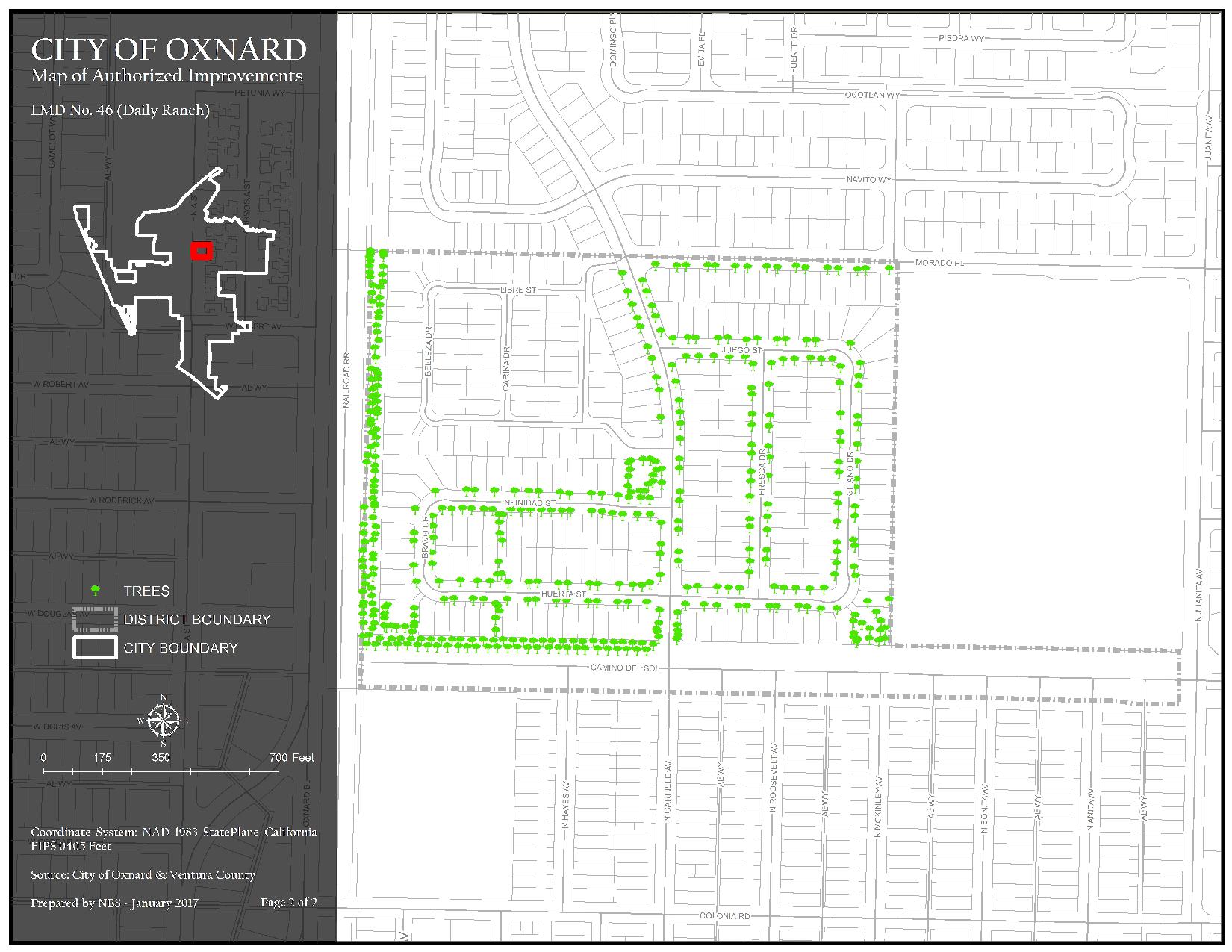
LMD 46 Daily Ranch Map 2 of Authorized Improvements
Trees
297.73 KB JPG | Updated 04/03/24
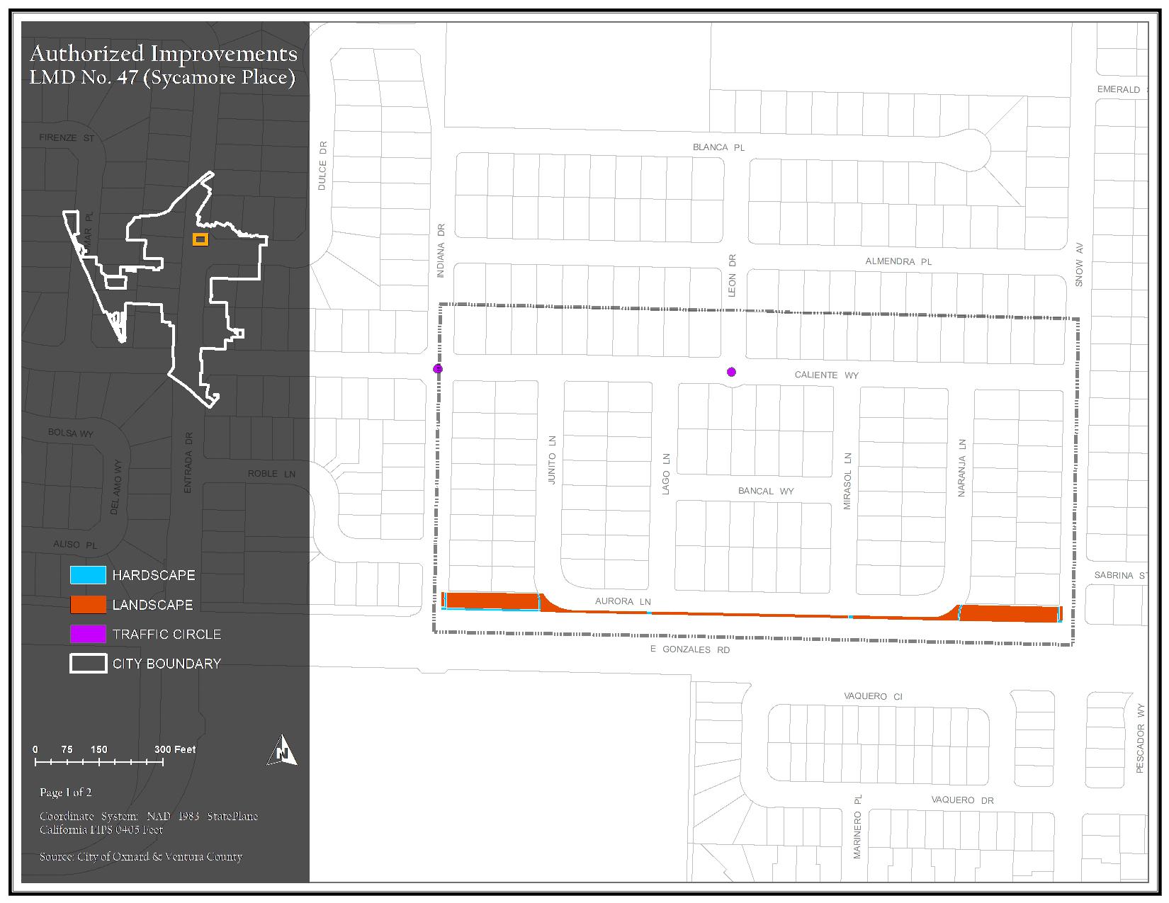
The district generally consists of property north of E. Gonzales Road, east of Indiana Drive, south of Caliente Way, and west of Snow Avenue. Assessments are imposed exclusively to finance capital costs, maintenance, and operation expenses associated with the repairs to trees, shrubs, turf, sidewalks, theme light poles, screen walls/fencing, medians, entry sign monuments, mailboxes, and ground cover.
Maintenance Service Levels
The current service level in LMD 47 Sycamore Place is Service Level A. For a detailed description of what your service level entails, please click the link below.
LMD 47 Sycamore Place Map 1 of Authorized Improvements
Hardscape, Landscape, and Traffic Circle
193.49 KB JPG | Updated 04/03/24
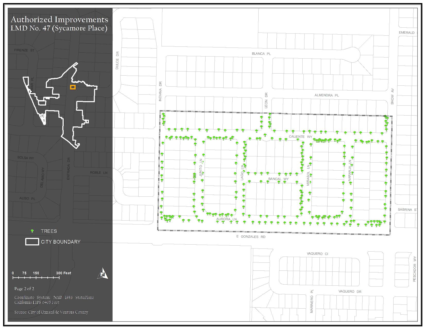
LMD 47 Sycamore Place Map 2 of Authorized Improvements
Trees
217.06 KB JPG | Updated 04/03/24
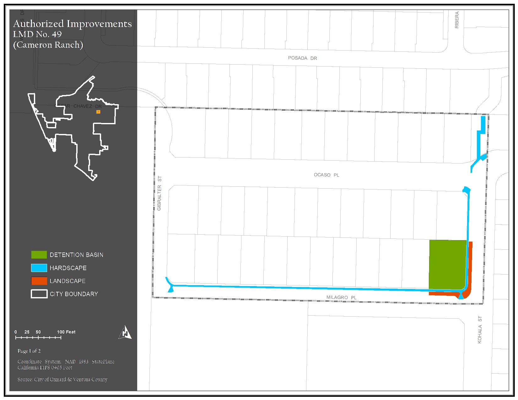
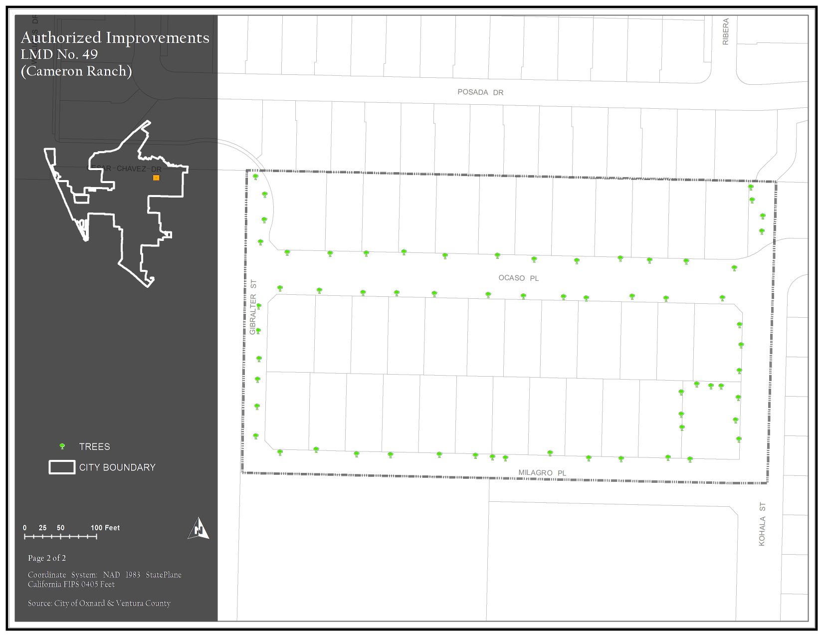
The district generally consists of property north of Milagro Place, east of Gibralter Street, along and south of Ocaso Place, and west of Kohala Street. Assessments are imposed exclusively to finance capital costs, maintenance, and operation expenses associated with the repairs to trees, shrubs, turf, sidewalks, theme light poles, ornamental lighting, screen walls/fencing, medians, and ground cover.
Maintenance Service Levels
Landscape maintenance services in LMD 49 Cameron Ranch is currently being provided by City Staff
LMD 49 Cameron Ranch Map 1 of Authorized Improvements
Detention Basin, Hardscape, and Landscape
152.88 KB JPG | Updated 04/03/24
LMD 49 Cameron Ranch Map 2 of Authorized Improvements
Trees
148.08 KB JPG | Updated 04/03/24
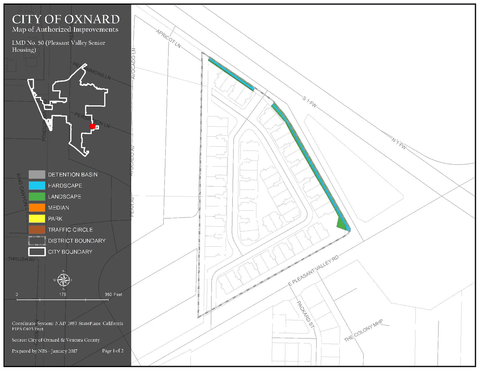
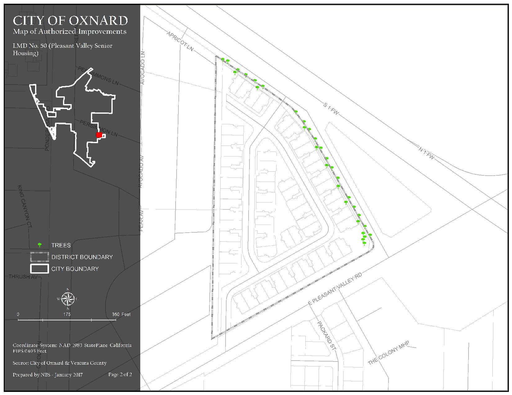
The district generally consists of property north of E. Pleasant Valley Road, east of Lemon Avenue, south and west of Butler Road. Assessments are imposed exclusively to finance capital costs, maintenance, and operation expenses associated with the repairs to trees, shrubs, turf, sidewalks, screen walls/fencing, and ground cover.
Maintenance Service Levels
The current service level in LMD 50 Pleasant Valley (PV) Senior Housing is Service Level A. For a detailed description of what your service level entails, please click the link below.
LMD 50 Pleasant Valley Senior Housing Map 1 of Authorized Improvements
Detention Basin, Hardscape, Landscape, Median, Park, and Traffic Circle
189.41 KB JPG | Updated 04/03/24
LMD 50 Pleasant Valley Senior Housing Map 2 of Authorized Improvements
Trees
182.2 KB JPG | Updated 04/03/24
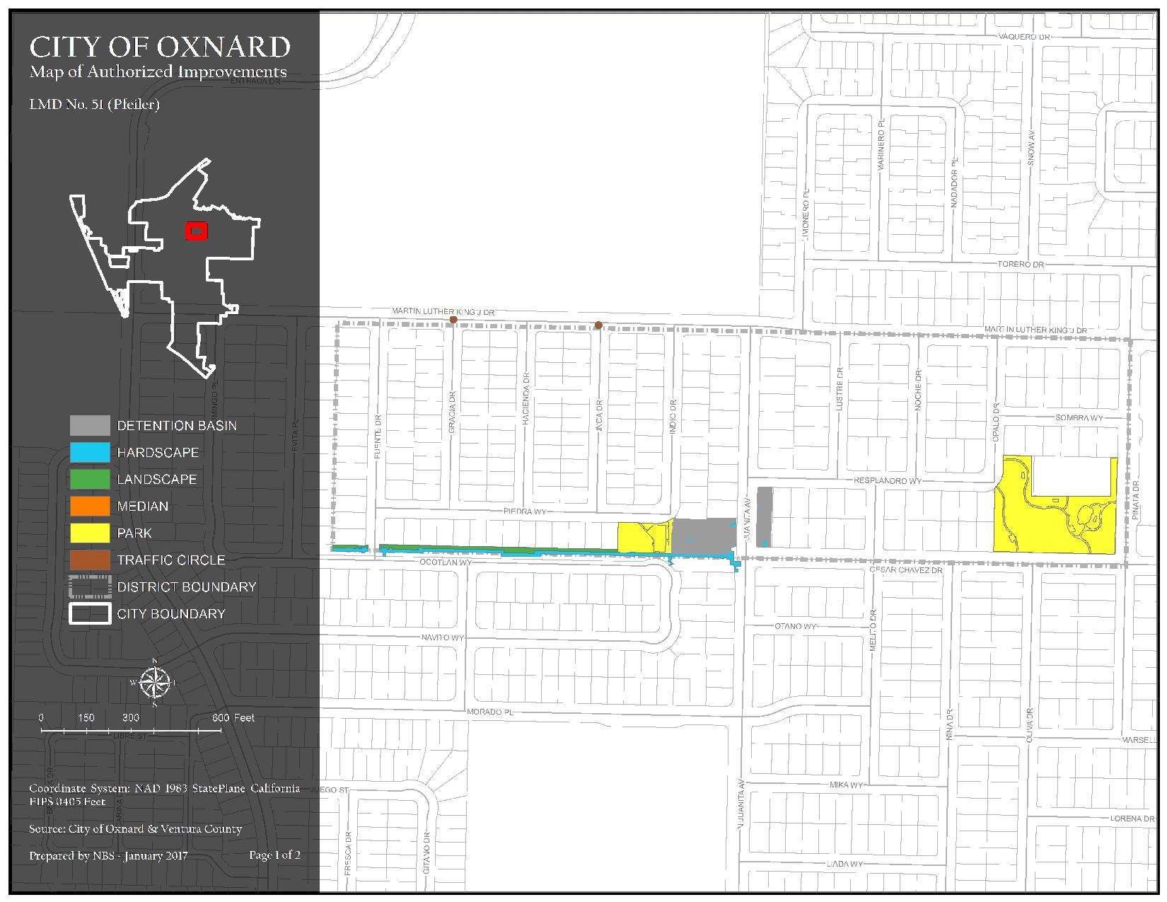
The district generally consists of property north of Cesar Chavez Drive, along and east of Fuente Drive, south of Martin Luther King Jr. Drive, and west of Pinata Drive. Assessments are imposed exclusively to finance capital costs, maintenance, and operation expenses associated with the repairs to trees, shrubs, turf, sidewalks, theme light poles, screen walls/fencing, mailboxes, detention basins, ground cover and Pfeiler Park amenities.
Maintenance Service Levels
The current service level in LMD 51 Pfeiler is Service Level A. For a detailed description of what your service level entails, please click the link below.
LMD 51 Pfeiler Map 1 of Authorized Improvements
Detention Basin, Hardscape, Landscape, Median, Park, and Traffic Circle
261.78 KB JPG | Updated 04/03/24
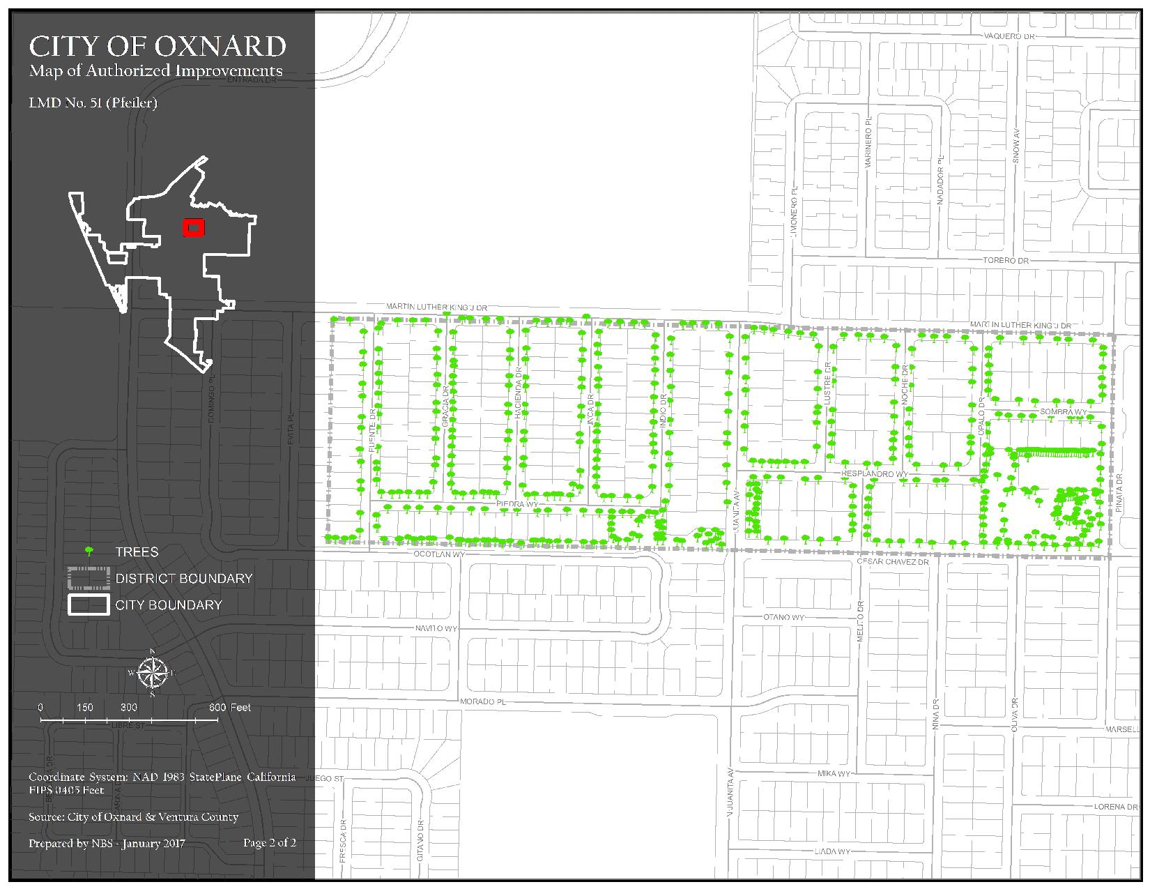
LMD 51 Pfeiler Map 2 of Authorized Improvements
Trees
290.61 KB JPG | Updated 04/03/24
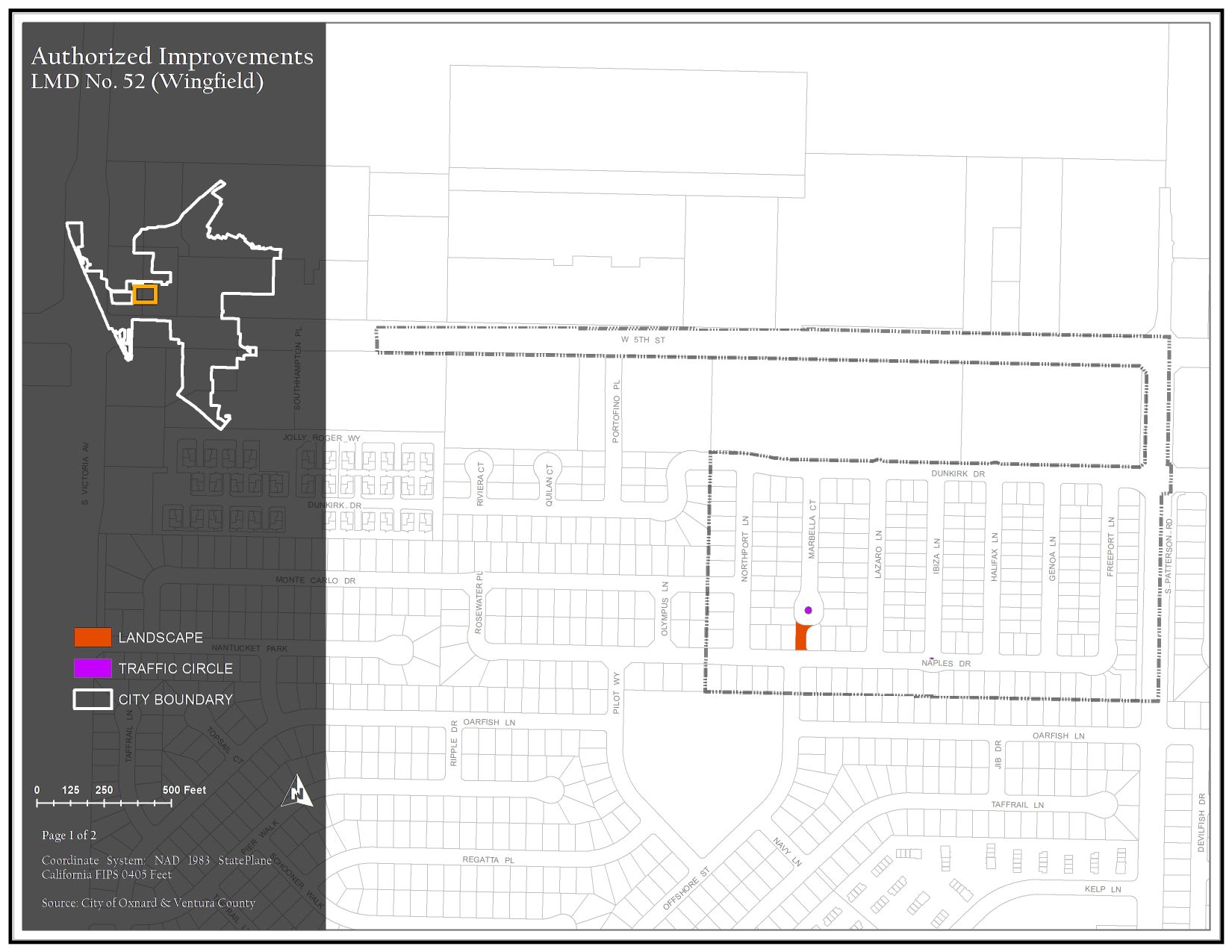
The district generally consists of property along and north of Naples Road, along and east of Northport Lane, south of Dunkirk Drive, and west of S. Patterson Road. Assessments are imposed exclusively to finance capital costs, maintenance, and operation expenses associated with the repairs to trees, shrubs, turf, sidewalks, ornamental lighting, medians, mailboxes, and ground cover.
Maintenance Service Levels
The current service level in LMD 52 Wingfield is Service Level A. For a detailed description of what your service level entails, please click the link below.
LMD 52 Wingfield Map 1 of Authorized Improvements
Hardscape and Landscaoe
218.95 KB JPG | Updated 04/03/24
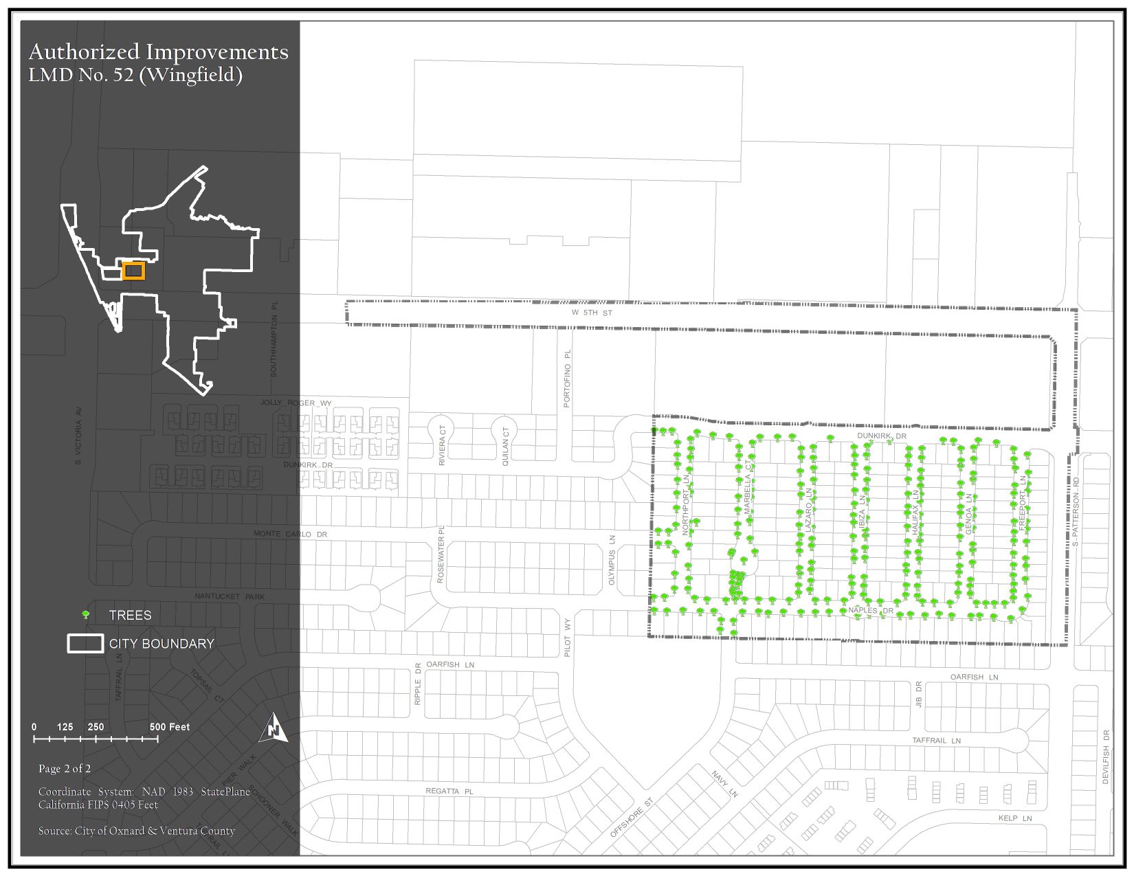
LMD 52 Wingfield Map 2 of Authorized Improvements
Trees
238.69 KB JPG | Updated 04/03/24
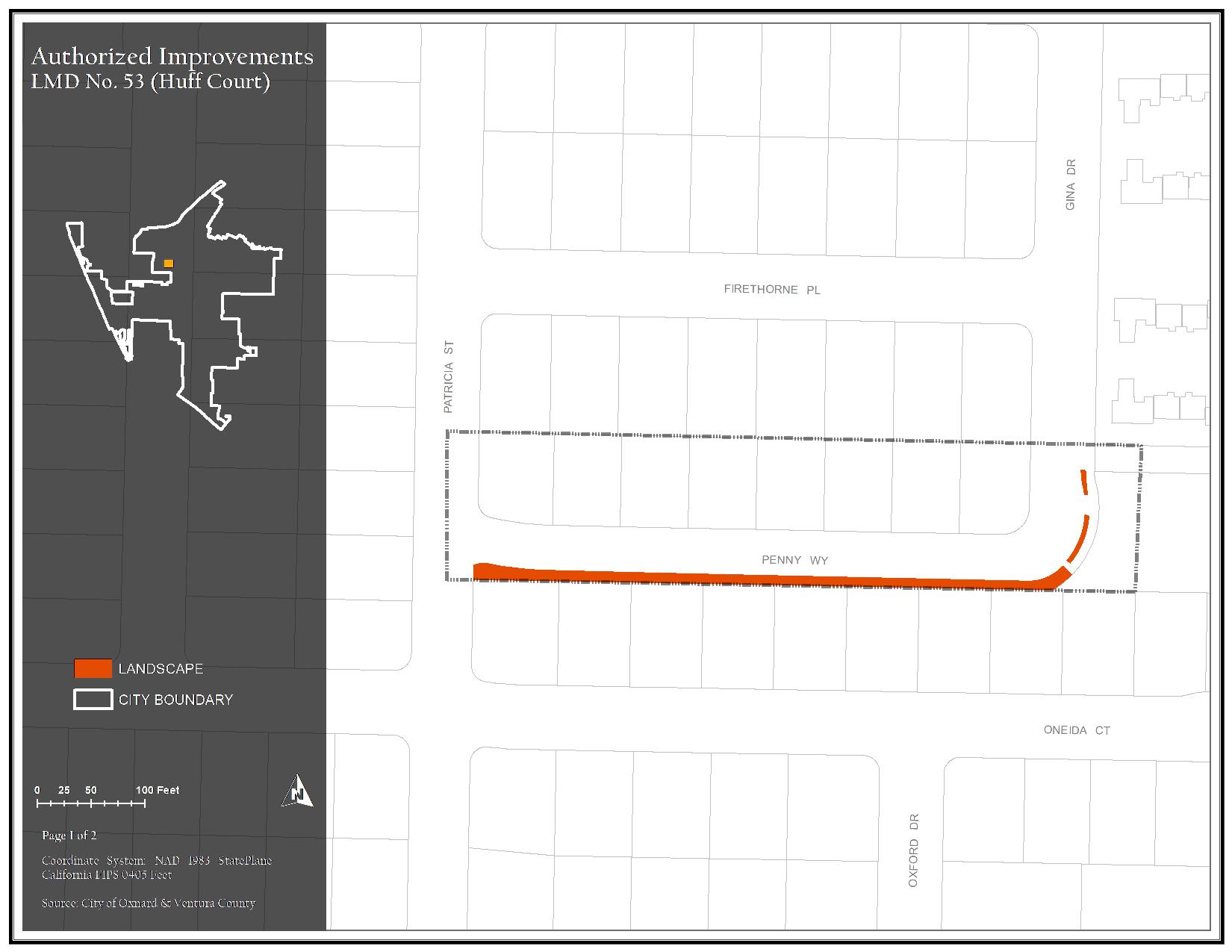
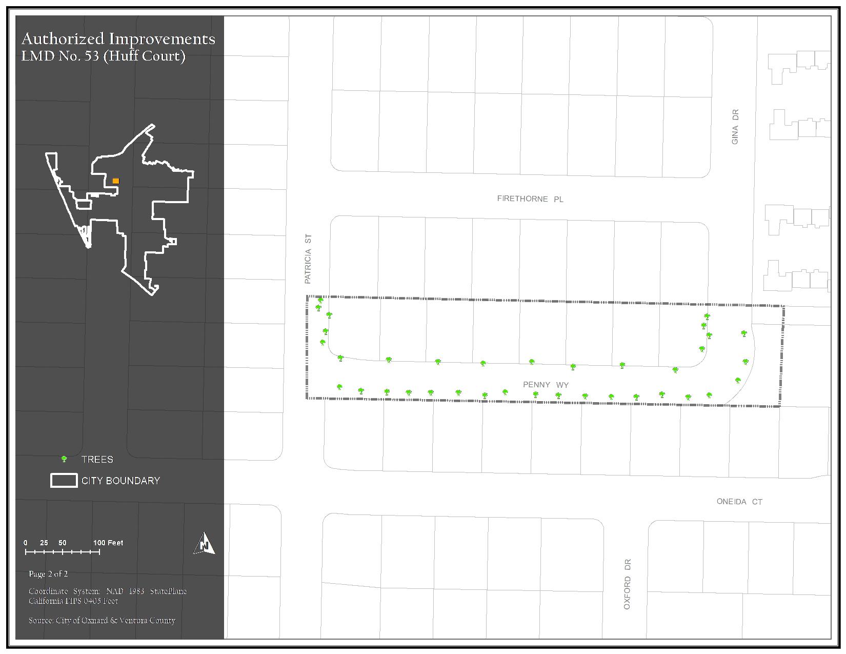
The district generally consists of property north of Penny Way, east of Patricia Street, south of Firethorne Place, and west of Gina Drive. Assessments are imposed exclusively to finance capital costs, maintenance, and operation expenses associated with the repairs to trees, shrubs, turf, sidewalks, ornamental lighting, screen walls/fencing, mailboxes, and ground cover.
Maintenance Service Levels
Landscape maintenance services in LMD 53 Huff Court is currently being provided by City Staff.
LMD 53 Huff Court Map 1 of Authorized Improvements
Landscape
143.13 KB JPG | Updated 04/03/24
LMD 53 Huff Court Map 2 of Authorized Improvements
Trees
144.04 KB JPG | Updated 04/03/24
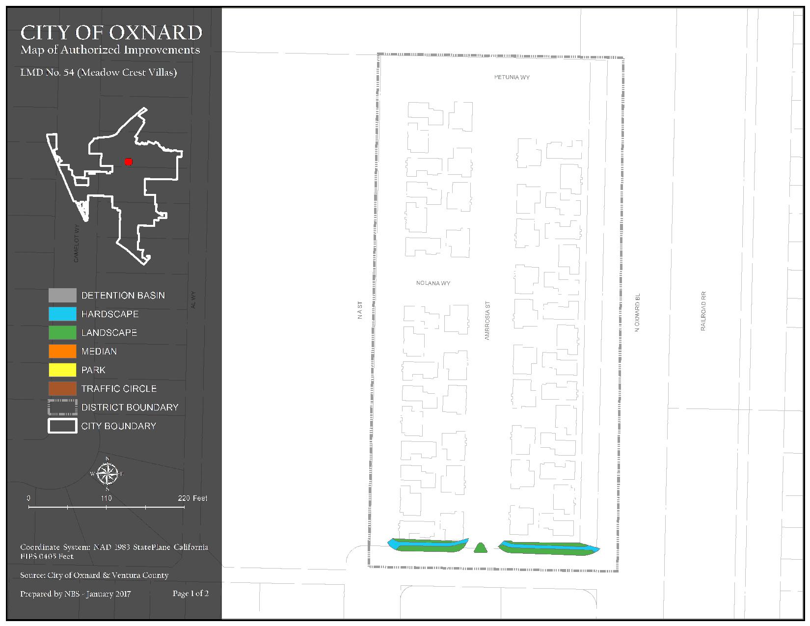
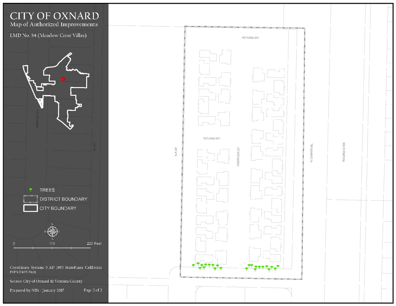
The district generally consists of property north of W. Robert Avenue, south and east of N. A Street, and west of N. Oxnard Boulevard. Assessments are imposed exclusively to finance capital costs, maintenance, and operation expenses associated with the repairs to trees, shrubs, turf, sidewalks, screen walls/fencing, and ground cover.
Maintenance Service Levels
The current service level in LMD 54 Meadow Crest Villas is Service Level A. For a detailed description of what your service level entails, please click the link below.
LMD 54 Meadow Crest Villas Map 1 of Authorized Improvements
Detention Basin, Hardscape, Landscape, Median, Park, and Traffic Circle
151.06 KB JPG | Updated 04/03/24
LMD 54 Meadow Crest Villas Map 2 of Authorized Improvements
Trees
143.79 KB JPG | Updated 04/03/24
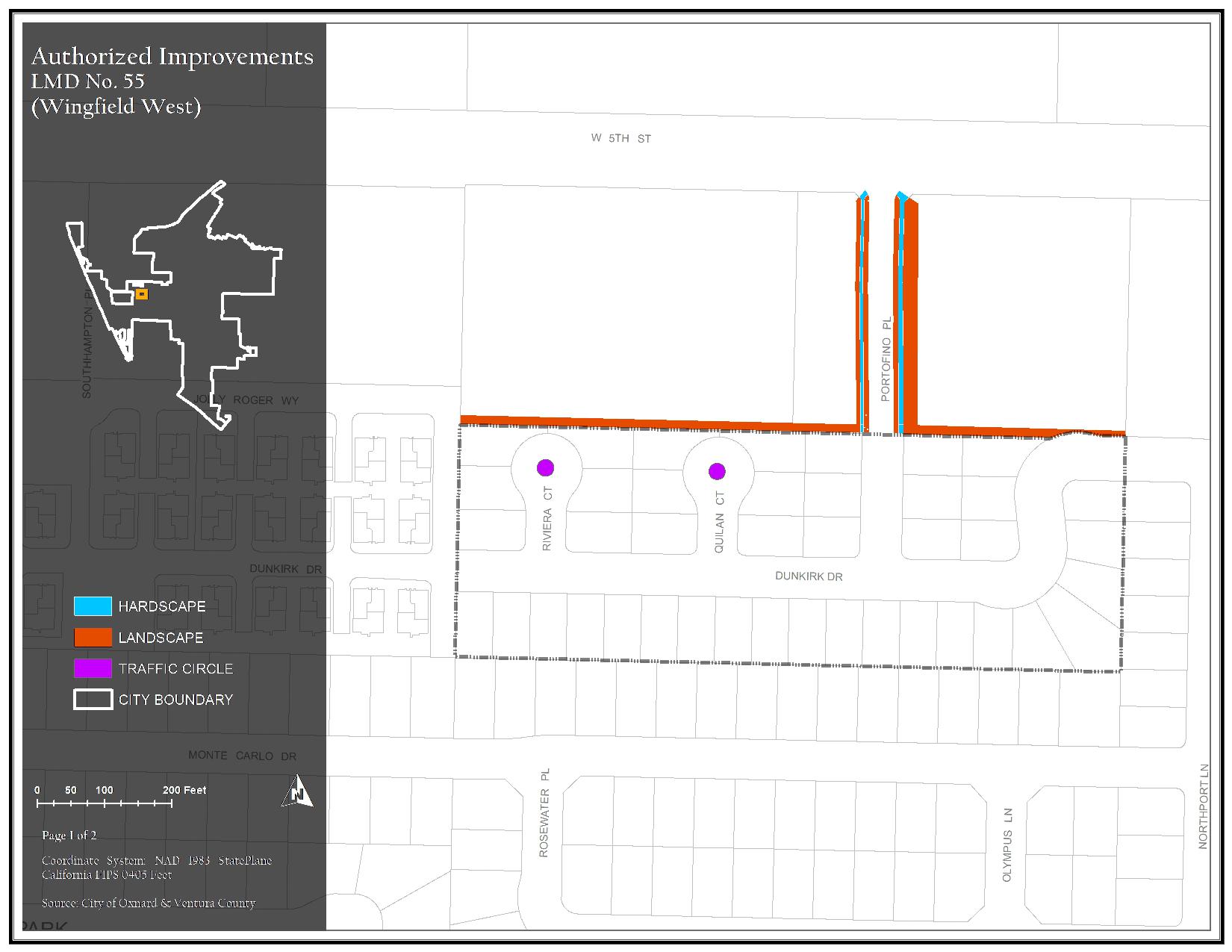
The district generally consists of property along and north of Dunkirk Road, east of Jolly Roger Way, south of W. Fifth Street, and west of Northport Lane. Assessments are imposed exclusively to finance capital costs, maintenance, and operation expenses associated with the repairs to trees, shrubs, turf, sidewalks, theme light poles, mailboxes, and ground cover.
Maintenance Service Levels
The current service level in LMD 55 Wingfield West is Service Level A. For a detailed description of what your service level entails, please click the link below.
LMD 55 Wingfield West Map 1 of Authorized Improvements
Hardscape, Landscape, and Traffic Circle
166.87 KB JPG | Updated 04/03/24
LMD 55 Wingfield West Map 2 of Authorized Improvements
Trees
1.27 MB PDF | Updated 04/03/24
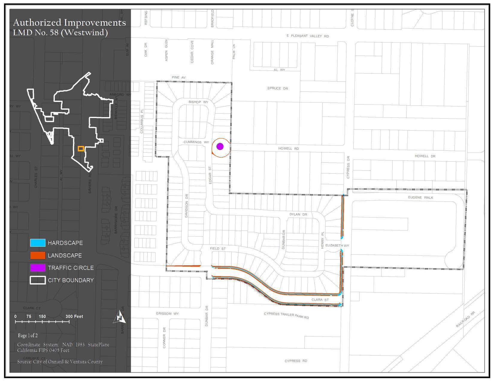
Road. Assessments are imposed exclusively to finance capital costs, maintenance, and operation expenses associated with the repairs to trees, shrubs, turf, sidewalks, theme light poles, ground cover and Garden City Acres Park amenities.
Maintenance Service Levels
The current service level in LMD 58 Westwind is Service Level A. For a detailed description of what your service level entails, please click the link below.
LMD 58 Westwind Map 1 of Authorized Improvements
Hardscape, Landscape, and Traffic Circle
162.16 KB JPG | Updated 04/03/24
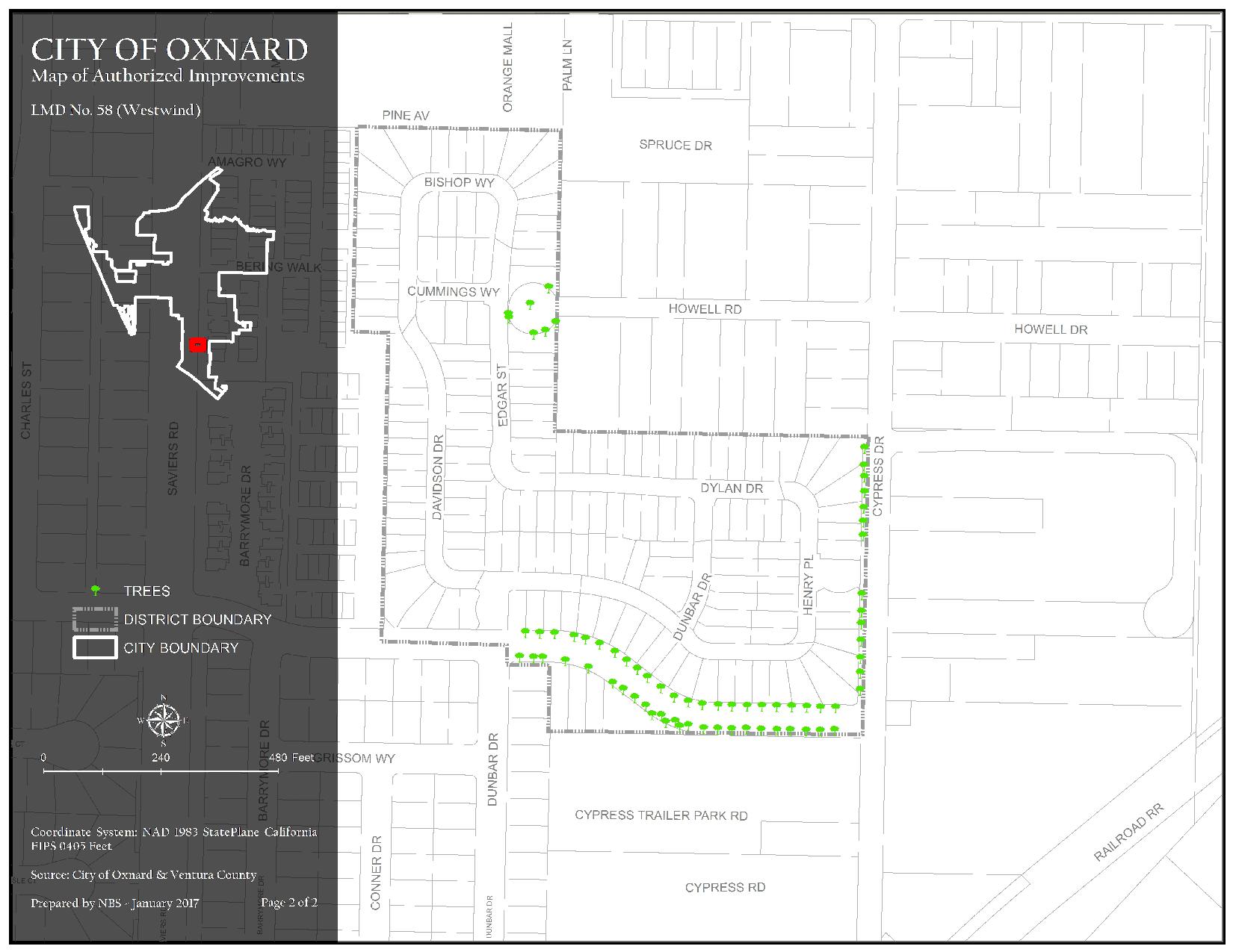
LMD 58 Westwind Map 2 of Authorized Improvements
Trees
212.95 KB JPG | Updated 04/03/24
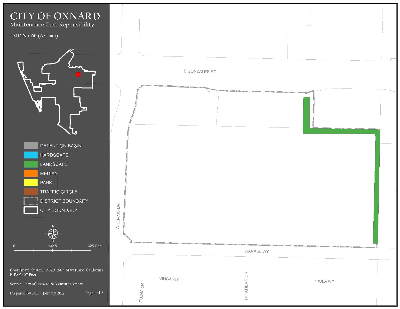
The district generally consists of property north of Wankel Way, east of Williams Drive, south of Gonzales Road, and west of N. Lombard Street. Assessments are imposed exclusively to finance capital costs, maintenance, and operation expenses associated with the repairs to trees, shrubs, turf, sidewalks, theme light poles, park benches, trash containers, doggie bag sections, overhead structures, screen walls/fencing, and ground cover.
Maintenance Service Levels
The current service level in LMD 60 Artisan is Service Level A. For a detailed description of what your service level entails, please click the link below.
LMD 60 Artisan Map 1 of Authorized Improvements
Detention Basin, Hardscape, Landscape, Median, Park, and Traffic Circle
123.84 KB JPG | Updated 04/03/24
LMD 60 Artisan Map 2 of Authorized Improvements
Trees
119.49 KB JPG | Updated 04/03/24